SEVERE THUNDERSTORM WARNING
for DESTRUCTIVE WIND, LARGE HAILSTONES and HEAVY RAINFALL
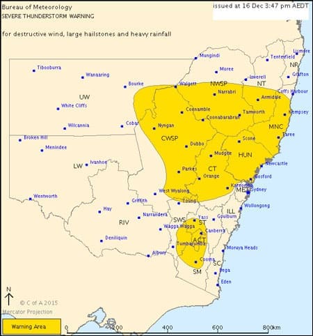
For people in the Mid North Coast, Hunter, Central Tablelands, Central West Slopes and Plains, Australian Capital Territory and parts of the Southern Tablelands, North West Slopes and Plains, South West Slopes, Upper Western, Snowy Mountains and Northern Tablelands Forecast Districts.
Issued at 3:47 pm Wednesday, 16 December 2015.
Severe thunderstorms are likely to produce destructive winds, large hailstones and very heavy rainfall that may lead to flash flooding over the next several hours in the Mid North Coast, Hunter, Central Tablelands, Central West Slopes and Plains and parts of the North West Slopes and Plains, South West Slopes, Upper Western and Northern Tablelands districts. Locations which may be affected include Port Macquarie, Taree, Newcastle, Gosford, Armidale, Orange, Tamworth and Dubbo.
Severe thunderstorms are likely to produce large hailstones and heavy rainfall that may lead to flash flooding over the next several hours in the Australian Capital Territory and parts of the Southern Tablelands, South West Slopes and Snowy Mountains districts. Locations which may be affected include Canberra, Cooma, Yass, Bredbo, Adaminaby and Tumut.
Severe thunderstorms are no longer occurring in the Metropolitan district and the warning for this district is CANCELLED.
Very destructive winds associated with a possible tornado affected the Sydney coast around Kurnell around 10:30am.
A wind gust of 213 km/h was recorded at Kurnell at 10:33am.
Wind gusts of 142 km/h was recorded at Molineaux Point (Botany Bay) at 10:45am, and of 111 km/h at Little Bay at 10:48am.
140 mm was recorded in the 50 minutes to 10:30am at Island Point Road (just south of Jervis Bay), and 68 mm at Vincentia in the same period.
53 mm was recorded in the 30 minutes to 1:45pm at Rose Bay.
Golf ball sized hail was reported at Cronulla around 10:30am.
2.5cm hail was reported at Blackheath around 12:15pm.
Wind gust of 102 km/h reported at Coonamble at 3.43 pm.
The State Emergency Service advises that people should:
* Move your car under cover or away from trees.
* Secure or put away loose items around your house, yard and balcony.
* Keep clear of fallen power lines.
* Keep clear of creeks and storm drains.
* Don’t walk, ride your bike or drive through flood water.
* If you are trapped by flash flooding, seek refuge in the highest available place and ring 000 if you need rescue.
* Unplug computers and appliances.
* Avoid using the phone during the storm.
* Stay indoors away from windows, and keep children and pets indoors as well.
* For emergency help in floods and storms, ring the SES (NSW and ACT) on 132 500.
The next warning is due to be issued by 6:50 pm.
If severe thunderstorms develop in Sydney Newcastle Wollongong or surrounding areas or Canberra and Queanbeyan, a more detailed Severe Thunderstorm Warning will be issued to people in these areas.
Warnings are also available through TV and Radio broadcasts, the Bureau’s website at www.bom.gov.au or call 1300 659 218. The Bureau and State Emergency Service would appreciate warnings being broadcast regularly.

